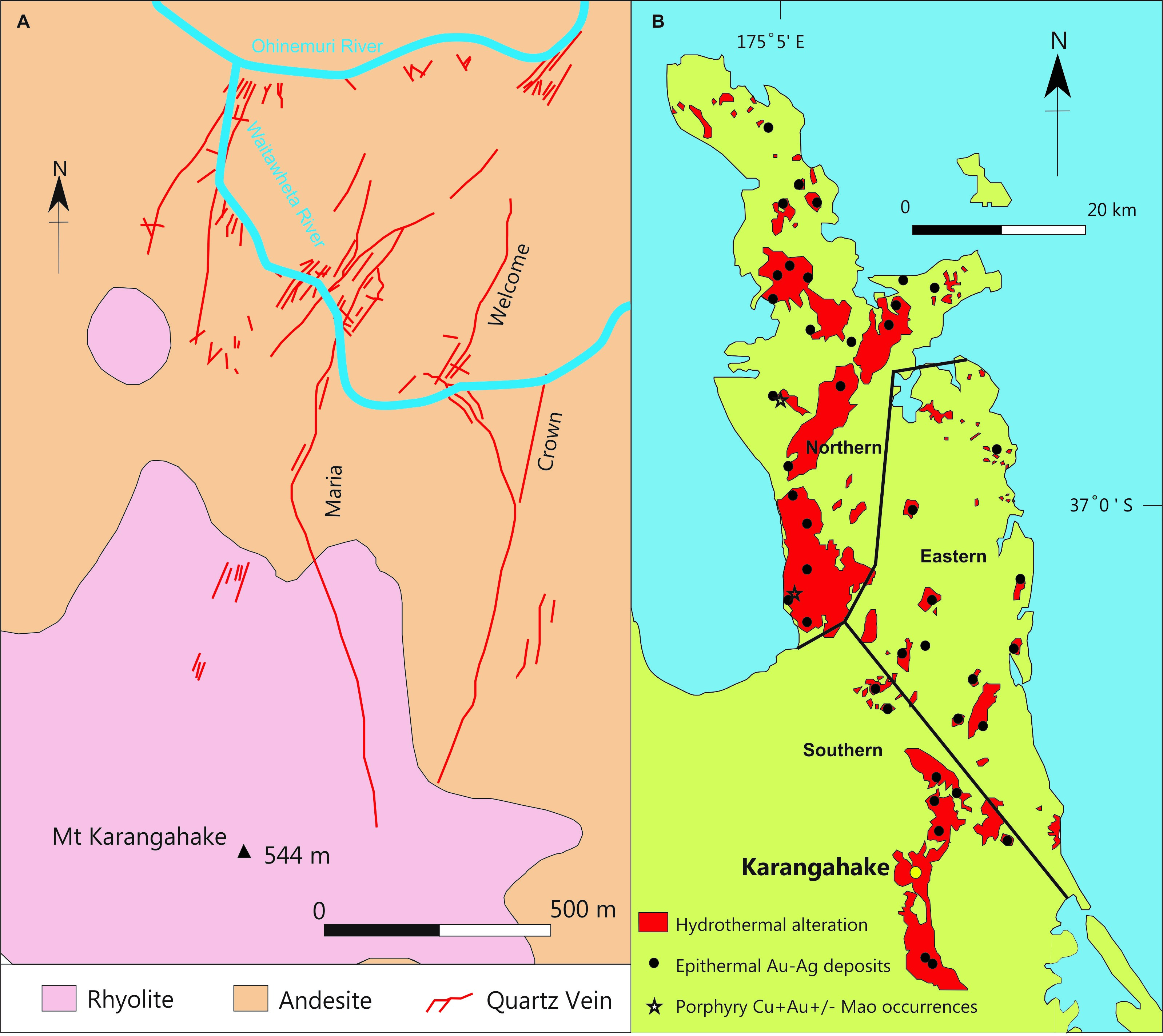
The Karangahake deposit is located in the southern portion of the Coromandel Peninsula (North Island, New Zealand), within the Hauraki goldfield, approximately 12 km east of Paeroa (Figure 1.1). The deposit is bound to the north by the Ohinemuri River and Coromandel Ranges and is centered on Mt Karangahake, which forms the northern extent of the Kaimai Ranges. The northern flank of Mt Karangahake is truncated by the Ohinemuri River and the eastern flank is truncated by the Waitawheta river, with historical mine workings continuing below river level.
REGIONAL GEOLOGY
The Talisman permit and the Karangahake Gold Project are located in the southern part of the Coromandel Volcanic Zone (CVZ), a north northwest trending zone of Miocene to early Quaternary sub-aerial calc-alkaline volcanics. The permit area covers part of the Karangahake gold-silver deposit, one of the major deposits of the Hauraki Goldfield, a 200 km long metallogenic zone of epithermal gold-silver and porphyry copper-gold mineralization that extends from Great Barrier Island in the north to as far south as Te Aroha and Te Puke. The volcanic rocks have been grouped into andesite and dacite, with associated intrusive rocks of the Miocene to Pliocene aged Coromandel Group and rhyolite of the late Miocene to Quaternary aged Whitianga Group. A north northwest trending, block faulted basement of Mesozoic greywacke underlies the volcanic rocks. This basement only crops out in the northern part of the CVZ although reports from early 20th century deep drilling at Karangahake mention intersecting greywacke beneath the No 16 level of the Talisman Mine.
Ash and pumice that erupted from the Taupo Volcanic Zone and Mayor Island over the last 100,000 years blanket much of the permit area to a depth of up to 8m, which is an impediment to exploration.
PROJECT GEOLOGY
The area is dominated by andesite and dacite of the Miocene aged Waipupu formation, part of the Coromandel Group, and the lithologies that host most of the known mineralisation. They consist of phyric plagioclase two-pyroxene andesites and dacites that are frequently autobrecciated and in places columnar jointed.
At Mt Karangahake, the Coromandel Group rocks are overlain by a 200m thick rhyolite cap, correlated with the Maratoto Rhyolite and the Rahu Formation to the north. These rocks are younger than the andesitic Waipupu Formation, but are correlated with the Waiwawa Sub-group. The local basement is Mesozoic aged greywacke.
At Rahu, Coromandel Group rocks are exposed in the southern and central parts, but much of the prospect is blanketed by rhyolitic volcanics and lake sediments of the Rahu Formation. The elevation of the contact between Coromandel Group andesites and the rhyolitic rocks at Karangahake and Rahu indicates that Rahu may have been relatively downthrown by about 200m by a fault through the Karangahake Gorge. Unaltered flows of the Whakamoehau Andesite of the Omahine Sub-group are exposed in the northeast, where they overlap some of the rhyolitic Rahu Formation.
The Karangahake project lies within a major north northeast trending structural corridor that hosts several other epithermal gold deposits including Golden Cross, Komata, Owharoa, Wharekiraponga and Onemana.
The main fault trends, as mapped from crush zones and air photos, are northwest, north-south, north northeast and east-west. The north-south and north northeast faults and associated quartz veins are earlier than the east-west and northwest faults, with the latter usually displacing the major quartz veins by no more than a few metres (but up to 15 m has been observed). It has been postulated that the northwest structures, where the most recent movement is post mineral, may have been active before and during mineralizing events, and provided the structural regime for the north to
northeast emplacement of the mineralized quartz veins in dilatent zones.
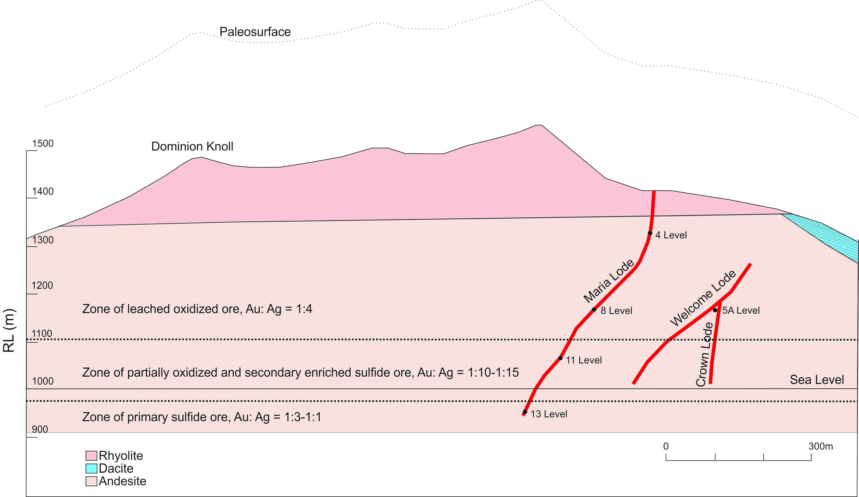
The main mineralised structures are the Maria Vein, Mystery Vein and Welcome/Crown Vein. The footwall extension of the Welcome Vein is located approximately 100m to the east and is called the Crown Vein.
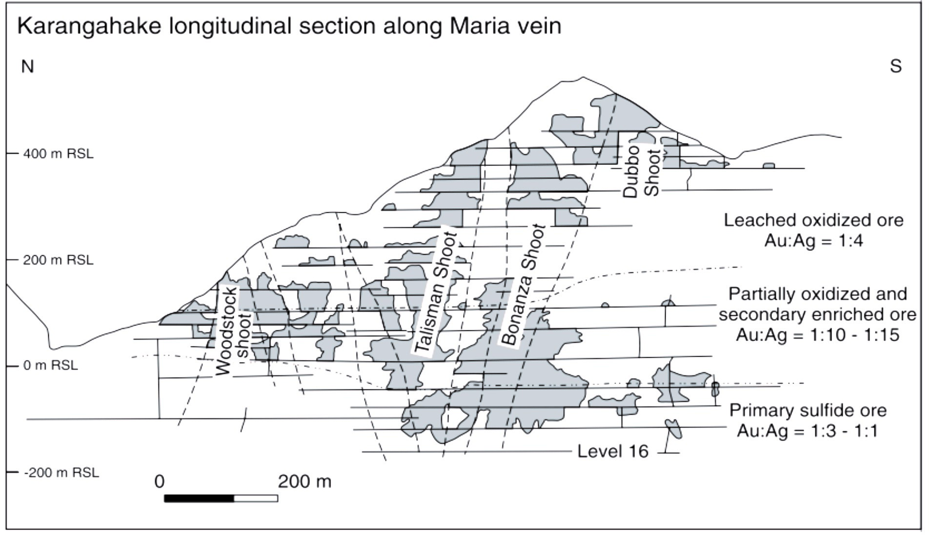
Historically the Karangahake deposit was divided into separate mines focused on different gold bearing veins or lodes: the Crown mine, and; the Talisman Mine. The lodes are sub-parallel, trending north-northeast. Mining has followed the Welcome/Crown and Maria veins along strike with the Welcome/Crown veins defining the eastern extent of the mine and the Maria vein defining the western extent of the mine. The Mystery Vein (approx. 1m width) is located in between these two vein systems and was discovered in the late 1980’s during the formation of the Keillor’s cross-cut, which connects the Maria vein to the Welcome/Crown vein. Historically, mining has focused along 4 sub-vertical ore shoots along the Maria Vein (Woodstock, Talisman, Bonanza, and Dubbo; Figure 1.3).
The Mystery vein has never been mined and is one of the potential resource blocks considered for future mining. In addition, after the main mining period ended, two unstoped regions along the Maria vein were considered potential economic resources and have been the focus of most subsequent exploration since the late 1980’s. The first area, historically referred to as “Block 1” is within the Woodstock shoot. The second area was discovered by the Cyprus drill hole BM37, which found bonanza grade gold and is termed the Dubbo block (Ian R. Brown Associates Ltd., 1989).
Exploration
Exploration in the modern era commenced when Southern Cross Minerals were granted the mining license from 1971-1992, focusing on reopening the old Talisman workings, predominantly the No. 8 level (Talisman) and higher levels to a lesser extent. During the time that it held the licence the company involved a number of partners Homestake NZ Exploration Ltd, New Zealand Goldfields and Cyprus Gold New Zealand Ltd. and carried out extensive sampling programs on the surface and underground and it is during this period that the occurrence of the Mystery vein was discovered while developing Keillors Cross-cut to connect the workings on No 8 Level of the Talisman Mine with the 5A Level workings at Crown Mine. A total of 73 diamond drill holes were drilled in the area (Ian R Brown Associates Ltd., 1992).
From 2004 to 2008 New Talisman Gold carried out a two phase exploration program along the number 8 level, The first phase focussed on the No 8 level of the Talisman mine and the 5A level of the Crown mine. The programme commenced in late November 2003 with the field work largely completed by mid 2004.
Data compilation, resource modelling, reporting and planning the second phase of the programme continued through 2004 with an underground drilling programme commencing in September 2004. This second phase programme completed to 31 March 2006 with announcement of a 200,000 Oz Gold resource reported in compliance with the JORC Code 2004.
The Karangahake deposit is located in the southern portion of the Coromandel Peninsula (North Island, New Zealand), within the Hauraki goldfield, approximately 12 km east of Paeroa (Figure 1.1). The deposit is bound to the north by the Ohinemuri River and Coromandel Ranges and is centered on Mt Karangahake, which forms the northern extent of the Kaimai Ranges. The northern flank of Mt Karangahake is truncated by the Ohinemuri River and the eastern flank is truncated by the Waitawheta river, with historical mine workings continuing below river level.
REGIONAL GEOLOGY
The Talisman permit and the Karangahake Gold Project are located in the southern part of the Coromandel Volcanic Zone (CVZ), a north northwest trending zone of Miocene to early Quaternary sub-aerial calc-alkaline volcanics. The permit area covers part of the Karangahake gold-silver deposit, one of the major deposits of the Hauraki Goldfield, a 200 km long metallogenic zone of epithermal gold-silver and porphyry copper-gold mineralization that extends from Great Barrier Island in the north to as far south as Te Aroha and Te Puke. The volcanic rocks have been grouped into andesite and dacite, with associated intrusive rocks of the Miocene to Pliocene aged Coromandel Group and rhyolite of the late Miocene to Quaternary aged Whitianga Group. A north northwest trending, block faulted basement of Mesozoic greywacke underlies the volcanic rocks. This basement only crops out in the northern part of the CVZ although reports from early 20th century deep drilling at Karangahake mention intersecting greywacke beneath the No 16 level of the Talisman Mine.
Ash and pumice that erupted from the Taupo Volcanic Zone and Mayor Island over the last 100,000 years blanket much of the permit area to a depth of up to 8m, which is an impediment to exploration.
PROJECT GEOLOGY
The area is dominated by andesite and dacite of the Miocene aged Waipupu formation, part of the Coromandel Group, and the lithologies that host most of the known mineralisation. They consist of phyric plagioclase two-pyroxene andesites and dacites that are frequently autobrecciated and in places columnar jointed.
At Mt Karangahake, the Coromandel Group rocks are overlain by a 200m thick rhyolite cap, correlated with the Maratoto Rhyolite and the Rahu Formation to the north. These rocks are younger than the andesitic Waipupu Formation, but are correlated with the Waiwawa Sub-group. The local basement is Mesozoic aged greywacke.
At Rahu, Coromandel Group rocks are exposed in the southern and central parts, but much of the prospect is blanketed by rhyolitic volcanics and lake sediments of the Rahu Formation. The elevation of the contact between Coromandel Group andesites and the rhyolitic rocks at Karangahake and Rahu indicates that Rahu may have been relatively downthrown by about 200m by a fault through the Karangahake Gorge. Unaltered flows of the Whakamoehau Andesite of the Omahine Sub-group are exposed in the northeast, where they overlap some of the rhyolitic Rahu Formation.
The Karangahake project lies within a major north northeast trending structural corridor that hosts several other epithermal gold deposits including Golden Cross, Komata, Owharoa, Wharekiraponga and Onemana.
The main fault trends, as mapped from crush zones and air photos, are northwest, north-south, north northeast and east-west. The north-south and north northeast faults and associated quartz veins are earlier than the east-west and northwest faults, with the latter usually displacing the major quartz veins by no more than a few metres (but up to 15 m has been observed). It has been postulated that the northwest structures, where the most recent movement is post mineral, may have been active before and during mineralizing events, and provided the structural regime for the north to
northeast emplacement of the mineralized quartz veins in dilatent zones.
The main mineralised structures are the Maria Vein, Mystery Vein and Welcome/Crown Vein. The footwall extension of the Welcome Vein is located approximately 100m to the east and is called the Crown Vein.
Historically the Karangahake deposit was divided into separate mines focused on different gold bearing veins or lodes: the Crown mine, and; the Talisman Mine. The lodes are sub-parallel, trending north-northeast. Mining has followed the Welcome/Crown and Maria veins along strike with the Welcome/Crown veins defining the eastern extent of the mine and the Maria vein defining the western extent of the mine. The Mystery Vein (approx. 1m width) is located in between these two vein systems and was discovered in the late 1980’s during the formation of the Keillor’s cross-cut, which connects the Maria vein to the Welcome/Crown vein. Historically, mining has focused along 4 sub-vertical ore shoots along the Maria Vein (Woodstock, Talisman, Bonanza, and Dubbo; Figure 1.3).
The Mystery vein has never been mined and is one of the potential resource blocks considered for future mining. In addition, after the main mining period ended, two unstoped regions along the Maria vein were considered potential economic resources and have been the focus of most subsequent exploration since the late 1980’s. The first area, historically referred to as “Block 1” is within the Woodstock shoot. The second area was discovered by the Cyprus drill hole BM37, which found bonanza grade gold and is termed the Dubbo block (Ian R. Brown Associates Ltd., 1989).
Exploration
Exploration in the modern era commenced when Southern Cross Minerals were granted the mining license from 1971-1992, focusing on reopening the old Talisman workings, predominantly the No. 8 level (Talisman) and higher levels to a lesser extent. During the time that it held the licence the company involved a number of partners Homestake NZ Exploration Ltd, New Zealand Goldfields and Cyprus Gold New Zealand Ltd. and carried out extensive sampling programs on the surface and underground and it is during this period that the occurrence of the Mystery vein was discovered while developing Keillors Cross-cut to connect the workings on No 8 Level of the Talisman Mine with the 5A Level workings at Crown Mine. A total of 73 diamond drill holes were drilled in the area (Ian R Brown Associates Ltd., 1992).
From 2004 to 2008 New Talisman Gold carried out a two phase exploration program along the number 8 level, The first phase focussed on the No 8 level of the Talisman mine and the 5A level of the Crown mine. The programme commenced in late November 2003 with the field work largely completed by mid 2004.
Data compilation, resource modelling, reporting and planning the second phase of the programme continued through 2004 with an underground drilling programme commencing in September 2004. This second phase programme completed to 31 March 2006 with announcement of a 200,000 Oz Gold resource reported in compliance with the JORC Code 2004.
The Company acquired verifiable historic data not previously available of detailed geology and grade data from past mining. NTL compiled this into a digital database and completed geological and resource modelling. Several estimates were announced but after development activities discovered that more stoping had taken place in the 1980’s than previously known the Company undertook to get the resource estimates revised and peer reviewed. This shows a substantial indicated and inferred resource of more than 350,000 ounces of gold equivalent remains with plenty of upside potential. This 2012 JORC compliant resource completed in 2019 is tabulated below.
| Resource Category | Ore Zone/Vein | Tonnes | Grade g/t Bullion equivalent | Ounces Bullion equivalent |
| Indicated | Talisman Bonanza | 29,000 | 4.3 |
4,100 |
| Indicated | Dubbo | 15,000 | 9.0 | 4,400 |
| Indicated | Dubbo splay | 4,300 | 19.0 | 2,600 |
| Indicated | Woodstock | 35,000 | 5.1 | 5,600 |
| Indicated | Woodstock splay | 22,000 | 5.1 | 3,600 |
| Total Indicated | 110,000 | 6.0 | 20,000 | |
| Inferred | Talisman-Bonanza | 300,000 | 19.0 | 190,000 |
| Inferred | Dubbo | 150,000 | 23.0 | 110,000 |
| Inferred | Dubbo splay | 560 | 14.0 | 250 |
| Inferred | Woodstock | 62,000 | 5.6 | 11,000 |
| Inferred | Woodstock splay | 20,000 | 4.7 | 2,900 |
| Inferred | Mystery | 14,000 | 25.0 | 11,000 |
| Total Inferred | 550,000 | 19.0 | 330,000 | |
| Total Resources (* Crown excluded) | 660,000 | 17.0 | 350,000 | |
| Total Resources Crown included | 810,000 | 15.0 | 380,000 | |
Note: – Data sources include historic bullion samples, drill holes and underground channel samples
- Mineral Resources are reported on a 100% basis to a nominal 2.2 Bullion equivalent grams per tonne cut-off grade which was determined in 2017 based on estimates of mining costs, metallurgical recoveries, treatment and refining costs, general and administration costs, royalties, and commodity prices.
- Ounces are estimates of metal contained in the Mineral Resource and do not include allowances for processing losses.
- For reporting purposes, all resources are reported as equivalent bullion values, due to bullion values rather than gold and silver grades being the only grade information that is available for historic channel samples. Conversion of more recent gold and silver values to equivalent bullion values uses the formula: Equivalent bullion grade = Gold grade + (Silver grade * 0.031609), which is based on historical prices of gold and silver. The equivalent bullion value of the resource is the same as an estimated gold equivalent grade due to the manner in which the historic and modern bullion values have been determined. Bullion conversions by NTL were based on a constant gold price of at £4-6s-0d/oz or USD20.47/oz during the period of historical production. Silver prices ranged from USD 0.49 to USD 1.03/oz.
- Tonnage and grade measurements are in metric units. Gold ounces are reported as troy ounces. Rounding as required by reporting guidelines may result in apparent summation differences between tonnes, grade and contained metal content.